Planting is increasingly being recognized as a critical layer of our urban environment – one that contributes to mental and physical health, urban cooling, resilience and biodiversity. For designers, vegetation presents unique challenges in the curation of a complex natural system that changes over time. Despite recognition of the importance of urban vegetation, there has been a delayed development of technology and digital tools for planting design. This creates a challenge as well as an opportunity for those who are prepared to engage with available data and technologies.
Design methods are evolving as projects become increasingly complex and integrated, with multidisciplinary teams working in a shared virtual space. How can we reimagine the processes of planting design in this context? This may mean moving away from the fixed plan and taking an adaptive approach that connects parametrically to microclimate data, updating in response to each new revision of a BIM model. Below, we look at a series of digital experiments in planting design, from defining layouts with parametric tools to capturing learnings from real-world planting trials using spatial data.
Tools for tending virtual gardens
Currently, a wide variety of tools and techniques are being used across landscape architecture practices, from 2D CAD to complex environmental simulations and BIM models. The development of digital tools specifically for landscape architects is critical to advancing the goals of the profession and meeting the challenges of the future.1 While recent developments are encouraging, the design of species-rich and structurally diverse planting schemes in the built environment remains a specialization within a small discipline. With relatively little investment in the space from large software vendors, practices are turning to workarounds, hacks and single-developer plug-ins to meet their project needs. The following examples are just a snapshot of an industry that is undergoing rapid change.
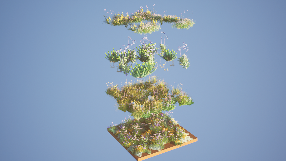
Land Kit, a plug-in for the popular Grasshopper and Rhinoceros software, was developed by artist, designer and visualizer Chris Landau, based on 15 years of working on landscape projects. Land Kit’s planting components use an innovative placement model to select the plant species that are most suitable for site-specific conditions. Plant selection is based on the user’s spatial design intent for layout, combined with a layered system of microclimatic analysis. These tools have been used on a range of projects under development to adapt planting schemes to soil and moisture conditions on site.

Chris Landau’s work on the Land Kit set of tools explores the possibility of planting that is responsive to a simulated site environment.
Image: Landau Design and Technology.
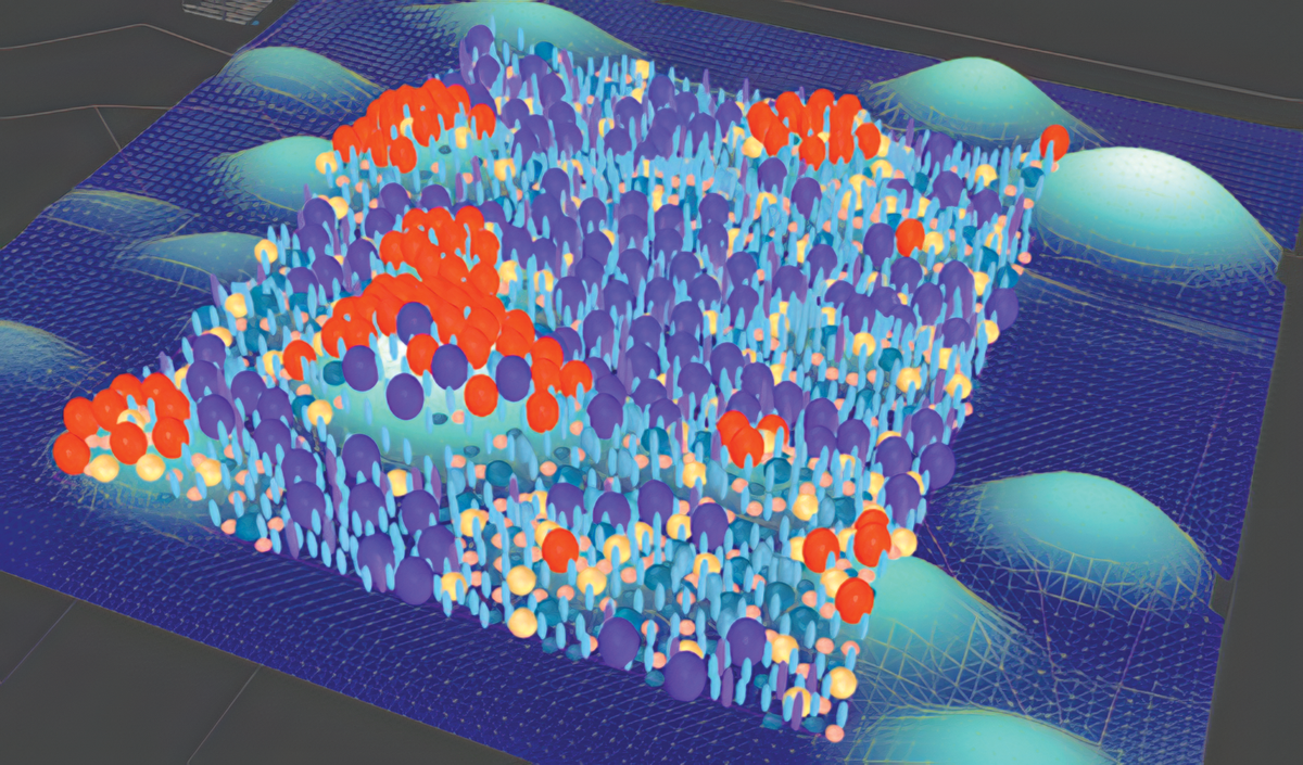
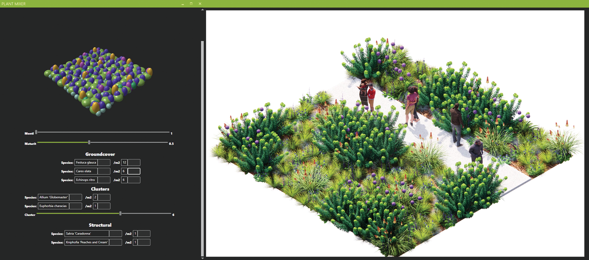
At Hassell, where I am an associate landscape architect, we have been exploring the possibilities of digital planting design through various design experiments and project work. The Plant Mixer app enables users to define planting mixes using parametric rules to describe the arrangement of plants in space. Linked to a digital library of plant characteristics and three-dimensional models, tools like this can enable quick visualization and exploration of planting palettes.
The expression of seasonality and change over time is an ongoing challenge for landscape architects, especially in projects involving large-scale public plantings, such as the Melbourne Arts Precinct Transformation. Hassell developed a simulation model for the project in Unreal Engine, allowing users to showcase the immersive experience of being within a dynamic seasonal landscape throughout the year in a real-time interactive model. This technology, originally developed for the video game and film industry, allows for highly detailed animated scenes, three-dimensional walk-throughs and virtual reality presentations.

Planting modules being developed in 3D with parametric rules in the Plant Mixer app.
Image: Michael G. White, Hassell
Connecting to plants on site with spatial data
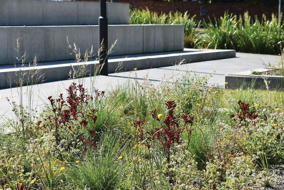
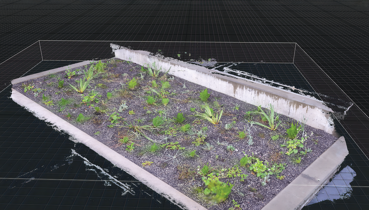
While digital tools can be powerful for visualization and communication, connecting to and visiting sites in the real world is critical to understand the changing patterns of plants over time. By collecting spatial data, building up a body of knowledge and revisiting past sites to observe how they have changed, we can glean valuable information to inform new projects. A recent collaboration between Sydney Metro, Hassell and the University of Melbourne resulted in an urban planting trial at the Hills Showground metro station in Castle Hill, Sydney that explores complex and diverse native planting mixes in a low-maintenance public environment. A point cloud scanning process was used to track progress and growth over a 12-month period, with a scan taken once every three months to record a point in time. Photogrammetry software Reality Capture was used to turn the photographs into a three-dimensional, full-colour capture of planting beds. These scans can be used to measure vegetation cover, track where species have survived or spread over time and even visit the past in virtual reality to interrogate how the site
has developed.
Such tools open up a new role for landscape architects, allowing them to engage as ongoing stewards of a digital site archive. Complex spatial data allows us to capture a point in time more effectively than any number of static images. Machine learning techniques can be used to measure growth and vegetation cover and analyse how these may be linked to underlying conditions on site. AI models can be trained to identify individual species, highlight invasive weeds and evaluate plant health. In the future, the increased availability of aerial and LIDAR (light detection and ranging) data will create even more opportunities for landscape architects to measure and learn from site after installation.

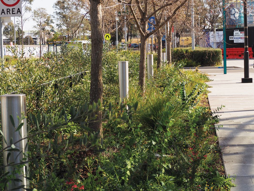
Dynamic seasonal planting at the Showground Planting Trials.
Image: J Hazelwood, Hassell

Dynamic seasonal planting at the Showground Planting Trials.
Image: J Hazelwood, Hassell
AI and planting design
The rapid rise of generative AI tools has been felt across every industry. Image and text generation can be powerful tools for conceptual explorations, saving considerable time. But unless they are grounded in well-labelled and robust datasets, ideally from local sources, they cannot provide reliable information. Generative imagery includes imagined plant species that have never existed outside digital space, and text output may hallucinate or falsify data on tolerances where it is not available. Training new systems on well-defined and validated datasets and annotated imagery will lead to more accurate results. At present, there are no available models trained specifically with the institutional knowledge of landscape architecture – but there will be.2 The unthinking use of generative tools may lead away from an evidence-based process, and the ability to critically evaluate generated outputs for quality and accuracy requires a deep knowledge of the medium.
Staying grounded
In the age of AI, developing the fundamental skills of planting design remains critical. It is impossible to adequately engage with planting design from behind a screen, without an understanding of growth, maintenance and change over time. Designers also need to be good communicators in order to be part of the conversation – and communicating will always include representing designs in 3D and coordinating projects in the digital space.
In the future, new tools may transform the design industry further, but at present, issues with the reliability and sourcing of data is still proving a challenge. In practice, it is vital to be able to validate and trace decision-making. Opportunities lie in creating holistic approaches in which the construction and management stages of projects can feed back into a continually growing knowledge pool around plant-growth processes, as well as improved outcomes on site.
1. See Jela Ivankovic-Waters’ article, “Embracing the innovation debate,” in the May 2022 issue of Landscape Architecture Australia; landscapeaustralia.com/articles/embracing-the-innovation-debate.
2. See Philip Belesky’s article, “So predictable? AI and landscape architecture” in the May 2023 issue of Landscape Architecture Australia; landscapeaustralia.com/articles/so-predictable-ai-and-landscape-architecture-1.
Source

Practice
Published online: 14 Feb 2024
Words:
Michael G White
Images:
J Hazelwood, Hassell,
Landau Design and Technology.,
Michael G. White, Hassell
Issue
Landscape Architecture Australia, February 2024