Michele and Miquel are an architecture and landscape practice based in Toulouse, Barcelona and Kaoshiung. The practice works at the intersection of architecture, landscape and urban planning, at scales ranging from the human-oriented to the territorial. It has a particular interest in public projects sited in landscapes, urban or natural, that are undergoing marked processes of transformation. In anticipation of co-directors Michèle Orliac and Miquel Batlle’s upcoming appearance at the 2023 AILA Festival of Landscape Architecture in Adelaide, Landscape Australia editor Emily Wong spoke with them about specificity of site, their fascination with ecological processes and flows, and agricultural practices as inspiration.
Emily Wong: Could you briefly describe your practice – what are your backgrounds, and how did the practice start?
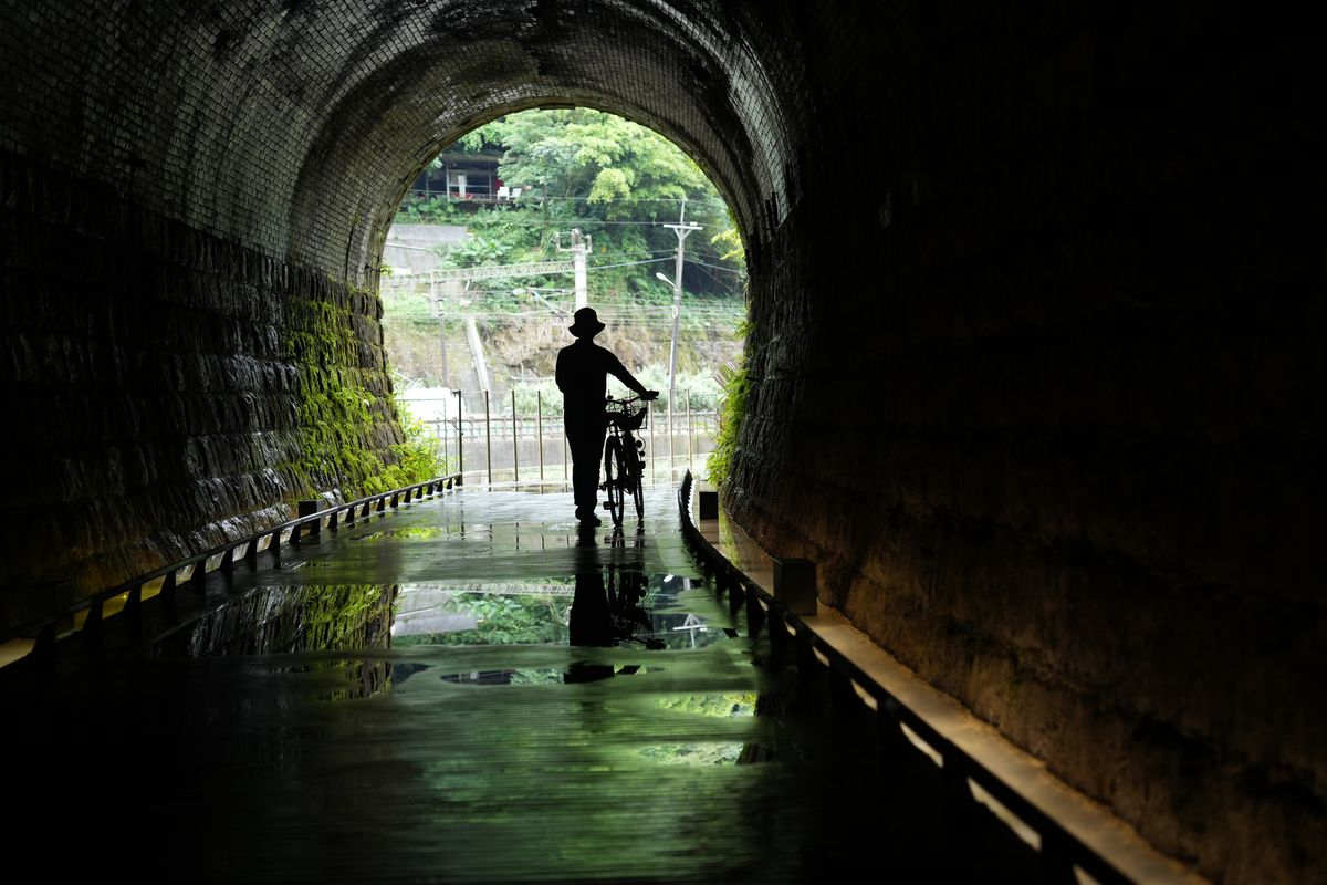
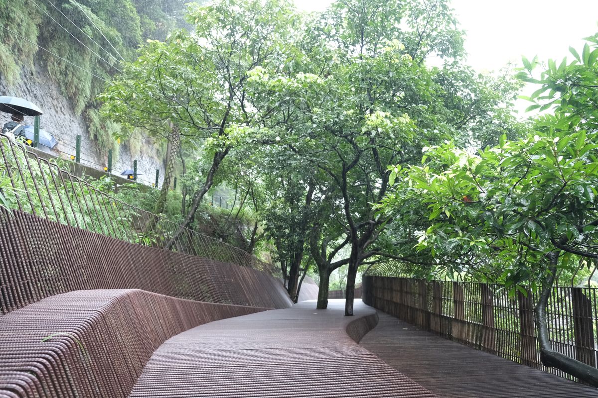
Michèle Orliac and Miquel Batlle: We are both architects, one of us having studied in France and the other in Spain. We met during the master’s degree in landscape architecture at the Barcelona School. Very quickly, we decided to work together on projects combining landscape, architecture and regional planning. From the outset, we based our proposals on the links between the history of the place and its geology, its geography, orography and ecology. [We focused on] how to make these aspects visible, when very often the growing urbanization of the last fifty years has tended to ignore and erase them. [When such erasure happens] this history becomes impossible to decipher by directly observing the environment. This approach is also the key to proposing sustainable developments, as it reinforces the profound nature of the site and takes into account its different temporalities – not just the temporality of human activities, but that of the climate, the seasons, [the processes of] sedimentation, [the flow of] the tides and animal [patterns]. This is what we have done, for example, in our project,The Dark Line, that was about enhancing the historic railway tunnels at Sandiaoling in Taiwan. We let the bats hang where they are used to hanging, the water flow where the topography makes it flow, the trees grow where they decide to grow, and the silt and stones continue to settle where the currents deposit them.

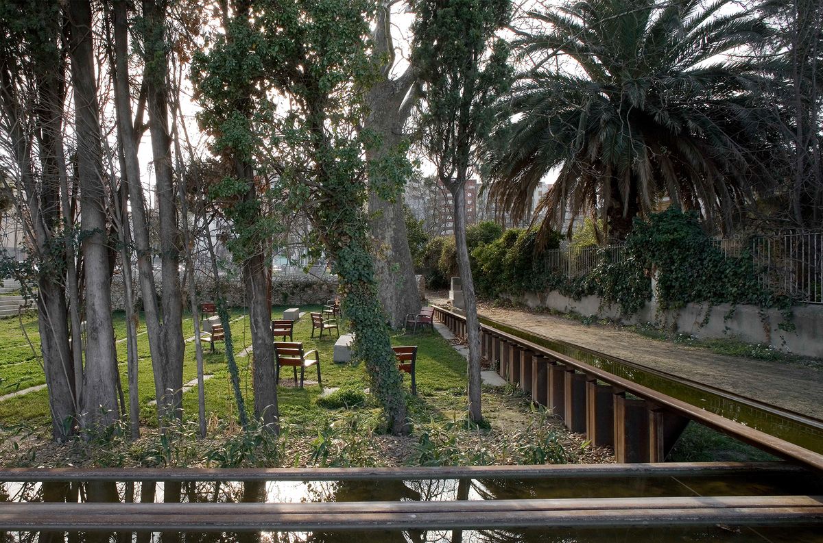
The design team’s approach for The Dark Line was to preserve the site’s historical and ecological depth, including soils that had accumulated, the seepage water run-off, the vegetation covering the façades, and all the trees.
Image: Michele and Miquel

At The Dark Line in Sandiaoling, Taiwan, bats hang, water flows through and trees continue to grow, just as they used to before the design team’s interventions.
Image: Michele and Miquel
That project was completed just last year. How did you come to it and what was the brief?
Our first impression of a place very often determines our attitude to the response we want to give. When we arrived at Sandiaoling, that impression was very strong – it was the impression ofan infrastructure [the tunnels] whose construction had clearly required considerable effort and energy, but which had been reduced to the state of a damp cave, abandoned to vegetation and bats, with a mouth now filled with sedimentary rock and silt. The decision was taken straight away to preserve this post-industrial landscape in all its historical and ecological depth, including the rocky and sandy soils that had accumulated over the course of the typhoons, the seepage water run-off, the luxuriant vegetation covering the monumental façades, and all the trees lining the route.
Accepting that this tunnel, where steam locomotives had once roared, had been transformed into a peaceful, humid cavern did not mean giving up on a historical interpretation. On the contrary, [such a transformation] broadens the spectrum of history. It is only when we see the trickling water, the invasive vegetation and the power of geological phenomena that the technical and human feat of this historic structure is fully revealed to an observer today. The passage of time here had produced ecological, atmospheric, acoustic, chromatic and luminous variations along the tunnel route, which formed the core of our proposal. But, despite this attitude of withdrawing in favour of the ambiences encountered, it must be said that heavy interventions were [still] required to open this route site to the public.
Your work in general suggests a particular interest in geology and the ground plane – paving patterns, lines, flows, textures, gradients, circulation, and edges. Where does this interest come from?
Working with the soil plays a major role in our projects. We consider the soil not as a surface but as a depth, a thick interface, a system that ranges from the cloud ten kilometres above our heads through drizzles and showers, to run-off, gullies, deposits, wet fermentation, infiltration, torrential and river run-off, deep water tables, slow geological transformation and into the progressive work of the flora and fauna that make [such soil] their habitat. The paving patterns, lines, textures, and gradients of our projects express the desire to create a kind of “filtering” soil, which can transform and allow its underground developments to appear on the surface. Geometry is a convenient, quick, and effective way to build a firm, hard floor, that can be traversed by both the elderly and the young. Such layouts [also] allow the use of modular elements that are easy to install according to simple rules. In a hard pavement of brick, concrete or stone, the insertion of gradations and soft lines, of filtering earth, allows flora and fauna to find a habitat and begin to erase this rigorous design, to pervert it. So, it’s a ground that’s very designed at the outset, but whose design is destined to be progressively invaded by the grasses and fauna, to be subjected to a certain uncontrolled wildness which slowly perverts it. In fact, the landscape is both a cultural product and an independent entity. What makes it up has its own development as a living being. This is what we want our work to reflect.

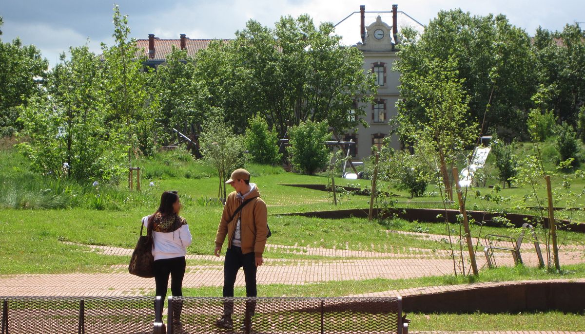
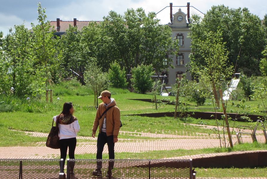
For Le Jardin Niel in Toulouse, France, Michele and Miquel used the spoils from the construction around the site to create a new soil, new topography and a new urban forest that recalls the site’s history of being a hill, prior being levelled for use as a parade ground.
Image: Michele and Miquel

Design interventions at Le Jardin Niel create a garden, an island of freshness on a former parade ground.
Image: Michele and Miquel
In recent years you’ve worked on a number of international projects in Taiwan and Senegal. What is your approach to working with international sites?
Our attitude towards a site is the same everywhere. But finding ourselves in contexts as different as Europe, Senegal or Taiwan forces us not to rethink our attitude to a site, but to abandon a certain number of reflexes from our work in Spain or France. Between Taiwan and the Mediterranean countries, for example, the context is very different – in Taiwan, the geomorphology, the excesses of climate, heat and rainfall that frequently lead to large-scale erosion and flooding, the presence of typhoons, the strength of the vegetation, the sounds, and, of course, the culture [is very different]. The Taiwanese also have a different approach to landscape. Public urban spaces, for example, are not really places to walk, except after dark. Beaches are not places to hang out, and the sea not where you often swim, because it’s too hot. All this context requires us to look for very different solutions.
You’ve designed a number of parks in Spain and France, including Parc de les Aigues, El Parc Bosc and Cap Roig El Parc and Le Jardin Niel. How does your design approach play out in these different projects?
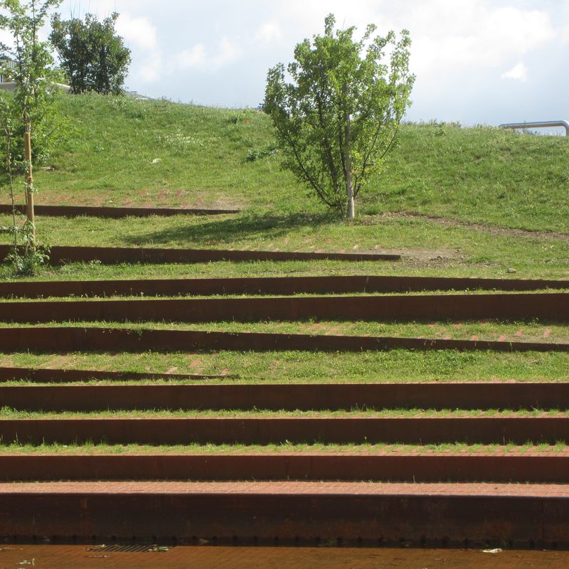
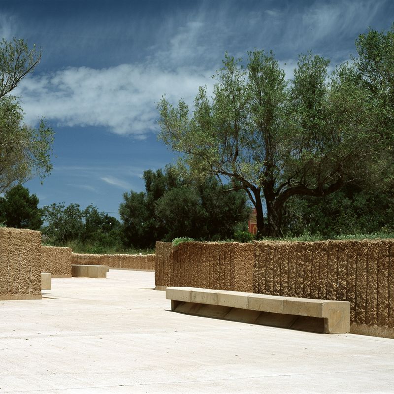
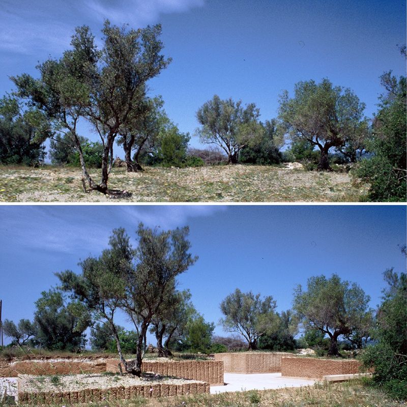
These projects respond to each other. Although very different in appearance, they proceed from the same attitude. Cap Roig in Tarragona and Parc de Les Aigues in Figueres, in particular, are a kind of mirrored version of each other. If in Cap Roig, it was too late to question the urban plan that had been provided to us, in Figueres on the other hand, we immediately proposed a complete modification of the planning work prior to our intervention. The Cap Roig project square is a kind of “pamphlet” project, that essentially shows that if you do not observe a soil, a topography, a vegetation very attentively, you can destroy everything with a seemingly innocuous gesture. In this case, for instance if you were to level and strip a Mediterranean plateau of just a few centimetres of earth, you would remove the thin layer of top soil and turn planted fields into an arid desert. Our proposal, which preserves a large rectangle of olive grove, says just that. In Figueres,on the contrary,we organized the park around the traces of the old system for managing the landform, rainwater and winds that had been put in place by the farmers of this former agricultural estate. We proposed to plant the flat blocks on the fields where wheat and oats used to grow. Here, there was no park to invent – the park already existed. It was enough to show it off, with its high windbreaks, its fountain and its basins to store water in case of drought, its orchard, its sunken paths …

At Parc de Les Aigues in Figueres, Spain, the design approach was to show off the landscape features that already existed – the site’s high windbreaks, its fountain, orchard, basins and sunken paths.
Image: Michele and Miquel

At Cap Roig in Tarragona, the designers preserved a large rectangle of olive grove as a square.
Image: Michele and Miquel
What are your main influences in landscape architecture – what are the ideas, practices and who are the practitioners that are informing your design approaches?
Our inspiration comes mainly from the work of farmers, who over the centuries have gradually transformed entire landscapes to make the most of the advantages offered by each site and reduce the effects of conditions unfavourable to their objectives. The terraced landscapes of Mediterranean countries, such as we found at Cap Roig, are a clear example of this. The succession of dry-stone walls geometrizes the relief, giving it a very strong aesthetic effect and at the same time solving many problems. The stones that make up the walls have been extracted from the land itself, leaving the topsoil to dominate the ground. In rainy weather, the walls retain the soil and prevent it from sliding down the slopes. They allow infiltration while letting the surplus percolate through the walls without joints like through a filter. The water passes through, but not the topsoil. In dry weather, these walls retain moisture from the slightest rain or dew. Surplus stones are piled up at the foot of olive trees, adding weight and helping them to resist strong winds that could uproot them. It is this detailed understanding of a site, its soil, climate and geology, and this intelligence in using the resources immediately at hand that inspires us. This slow, meticulous, yet radical, transformation of the terrain gives rise to a different kind of landscape, but one of great character. We also draw inspiration from the layout of a mountain path, like those found in Ireland for instance, that are marked only by a slightly different arrangement of stones. Very simple and very effective.
Michèle Orliac and Miquel Batlle are speaking at the upcoming AILA Festival of Landscape Architecture, “Un/earth,” to be held in Adelaide from 19 to 22 October. To purchase tickets, go here.