Protected areas – lands and waters ostensibly dedicated to the protection of the world’s ecological and cultural heritage – can be found across 235 countries, often forming the “backbone” of conservation systems. Their origins began in the United States with the world’s first national park at Yellowstone in 1872. Perhaps lesser known is the fact that the renowned landscape architect Frederick Law Olmsted was responsible for their creation. In 1865, Olmsted visited Yosemite and penned Yosemite and the Mariposa Grove: A Preliminary Report, 1865, which led to the protection of Yosemite (technically as a state park) and the gazettal of Yellowstone through the enactment of the United States Statutes at Large in 1872.
One hundred and forty-nine years since Yellowstone’s establishment, Australia’s protected area system now covers an impressive 19.74 percent of the country’s landmass and performs a valuable role at both national and state level.1 Today’s protected areas, like those of yesteryear, still negotiate a balance between conservation objectives and recreational use. They protect threatened species and ecosystems, and provide insights into unfragmented landscapes. “Going bush” slakes our collective thirst for adventure and connection with place and each other, and protected areas attract significant numbers of international tourists and provide economic activity, particularly for the regions.
While not necessarily as embedded in the national park movement historically as their forebears in the USA, landscape architects in Australia continue to be a profession well positioned to plan for the balance between conservation and recreation. This has perhaps never been more apparent and urgent, in conditions amplified by accelerating climate change, species extinction and – more recently – the implications of visitors during the COVID pandemic.
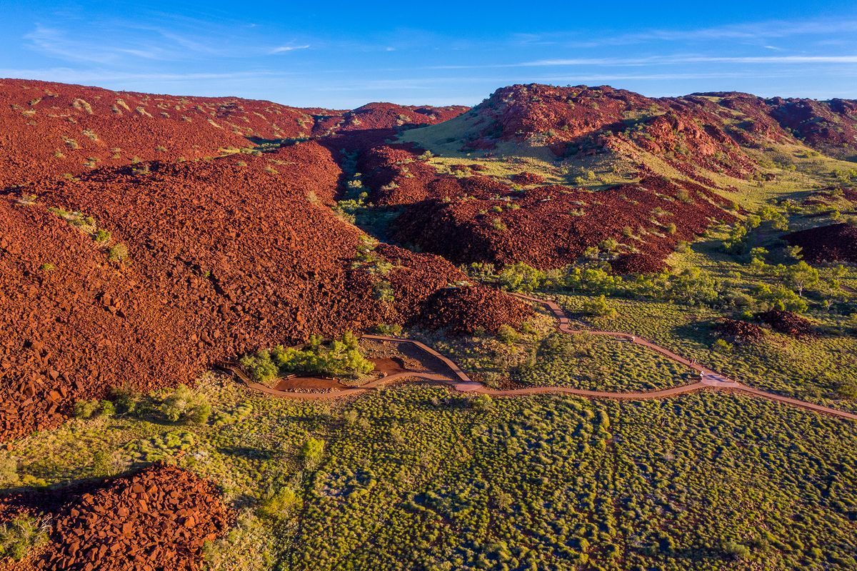
In Western Australia, a total of 1,814 protected areas constitute a whopping 23.39 percent of the state’s land and 24.4 percent of its waters.2 Larger in size than Thailand, France or Kenya, this is a diverse land protection system that includes the world-famous iconic national parks Purnululu and Karijini in the north, historic and urban parks such as John Forrest and Yanchep near Perth, and the towering karri forests around Pemberton and Walpole in the state’s south-west that background the world-famous wine and surf country of Margaret River. Attracting more than 19.68 million visitors per year, managing 3,624 bookable campsites and maintaining 34,271 kilometres of roads,3 the WA Department of Biodiversity, Conservation and Attractions (DBCA) plans, manages and protects this vast area through careful consideration of threatened species and ecosystem planning, fire management, and increasingly, joint management with Traditional Owners. As of 30 June 2020, there were 10 joint-management agreements across 34 parks and reserves, equivalent to 10 percent of the protected area estate.

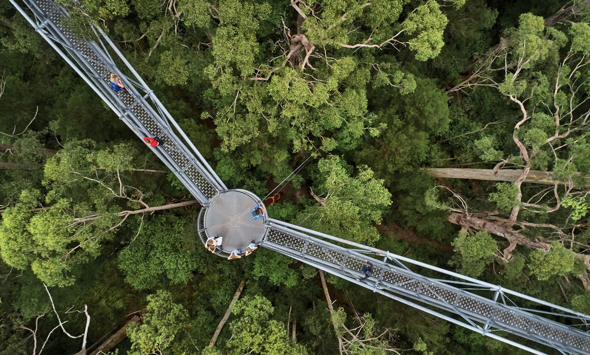
Visitors meander through the tops of mighty tingle and karri trees at the Valley of the Giants treetop walk.
Image: DBCA
This is a lot of land to consider and it is at the intersection between conservation and recreation planning that the department’s landscape architects have been most instrumental. With work mostly undertaken in-house, the department’s Recreation, Planning and Design Unit was formed in the 1980s by several landscape architects from the USA, including Wayne Schmidt and Richard Hammond. Eugene Herbert was also part of this early team, joined by Grant Revell, who brought visual landscape management and character assessment to the fore, through co-ordinating the publication Reading the Remote: Landscape Characters of Western Australia, a seminal work that offered the first detailed classification of landscape character at the state level.4 The publication was recognized with an Award of Excellence in the 1995 AILA WA Landscape Architecture Awards “Broad Environment” category.
Based in Perth, but operating via branches and offices throughout the state, the unit’s landscape architects provide input into statutory management plans and extensive, park-scale visitor-planning masterplans, and deliver site-scale detailed design services that consider the “what” and “where” of a spectrum of different recreational activities, including walking, mountain biking, drive trails, day-use areas, lookouts, campgrounds, visitor centres and other tourist infrastructure.

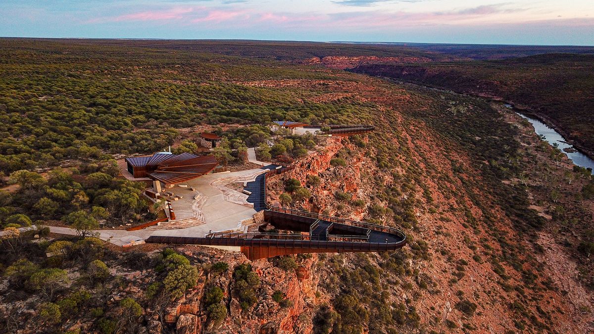
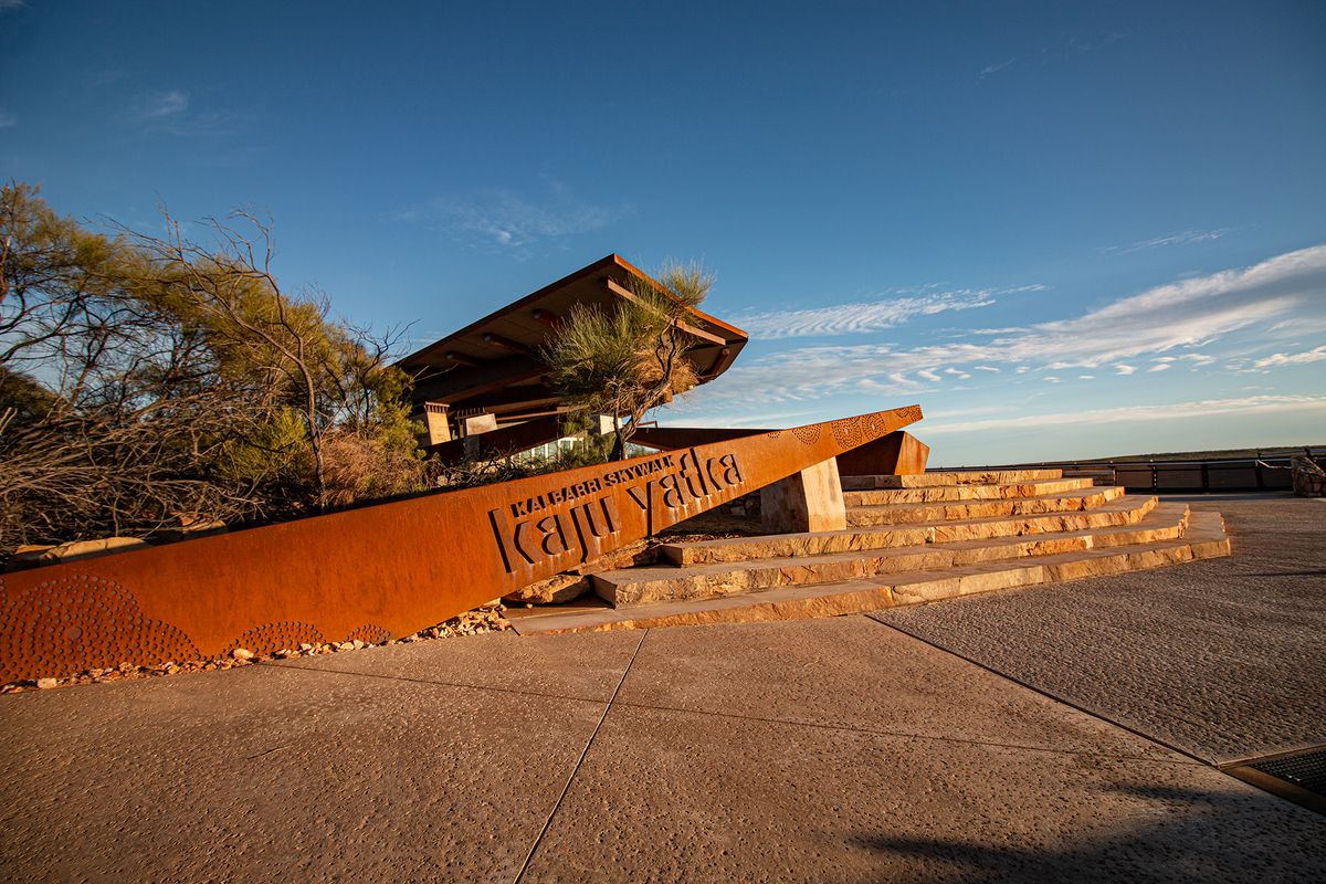
Two lookouts cantilevered over the Murchison River Gorge form the Kalbarri Skywalk and offer breathtaking views of the landscape and topography below.
Image: DBCA

Accessible paths are incorporated into the skywalk site, alongside more textural red sandstone stairs and access ways.
Image: DBCA
Timeframes for projects can be long and budgets tight. However, one of the key benefits of working in-house is the unique culture within the organization – a culture focused on building effective and lasting relationships. This collaborative spirit means working closely with a broad spectrum of the department’s architectural designers, ecologists, planners, rangers and in-house interpretive designers to ensure seamless “hand-in-glove” visitor messaging and information. Longevity of relationships is also the cornerstone of listening and respectfully planning with Traditional Owners and their knowledge, and the growing number of jointly managed parks – including Yawuru Conservation Parks, Nyinggulu (Ningaloo) Coastal Reserves and Murujuga National Park – are testament to this collaboration.
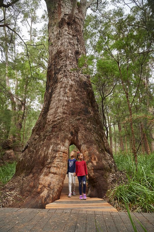
A project at the Valley of the Giants in Walpole-Nornalup National Park set an early benchmark for the unit’s skills and talent. A collaboration led by one of the department’s landscape architects with artist David Jones and architects Donaldson and Warn led to the creation of one of the world’s first treetop walks. This wheelchair-accessible structure delicately navigates a 600-metre-long path floating up to 40 metres above the ground through the treetops of tingle and karri trees, which can grow up to 85 metres in height. The walk, which is complemented by a ground-based interpretive trail of incredibly charismatic 400-hundred-year-old tingle trees, has won a spate of AILA and other awards, and arguably has been replicated throughout Australia and internationally. Nearby, Swarbrick – a site significant for its old-growth forest and historic logging conflicts – challenges visitors to rethink notions of wilderness through public art installations and interpretive features. (It won the 2008 AILA WA Excellence Award for Public Art.)
Several recently completed works articulate the continued conversation between the unit and department’s conservation and recreation objectives. For instance, the Kalbarri Skywalk, designed by Eastman Poletti Sherwood Architects in collaboration with DBCA and the land’s Traditional Owners and completed in late 2020, provides visitors with two stunning lookouts cantilevered 17 and 25 metres respectively over the Murchison River Gorge. It has picked up a range of awards, including a 2020 Australian Engineering Excellence Award and the Award of Excellence for Tourism at the 2021 WA Landscape Architecture Awards.
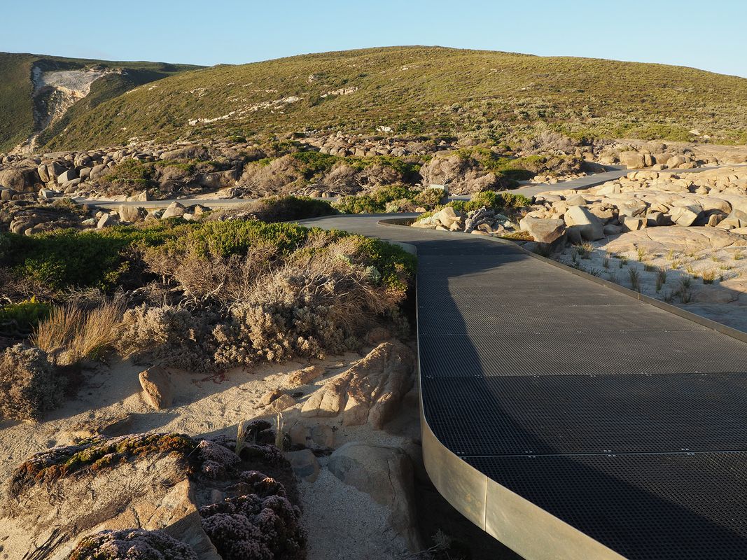
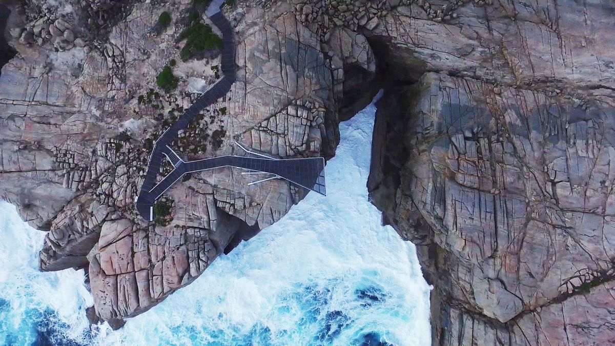
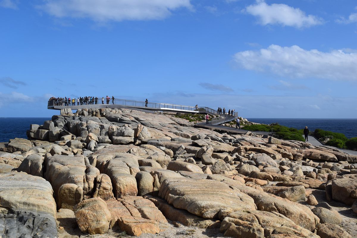
Similarly, The Gap and Natural Bridge near Albany provide a carefully planned, wheelchair-accessible experience that treads lightly on the land, while neatly mitigating several safety issues associated with a wild coastline. A raised pathway among granite boulders facilitates access to several viewpoints, including The Gap itself, a deep cleft to the dark blue Southern Ocean where the swell spectacularly smashes into the hard rock. Sensitively masterplanned, the project was detailed in-house and received an Award of Excellence in the Tourism category of the 2016 AILA National Landscape Architecture Awards.

Beneath the bridge’s cantilevered point, waves crash with immense force against the land’s edge.
Image: DBCA

Near Albany, The Gap and Natural Bridge traces a sensitive and wheelchair-accessible path to the edge of the granite cliffs.
Image: DBCA
The Bibbulmun Track and Munda Biddi are a hiking and a cycle trail that connect Perth with Albany – each trail spans more than 1,000 kilometres and is furnished with simple shelters, also designed in-house. The Bibbulmun Track is one of Australia’s oldest walking trails and harks back to the pathways once used throughout the state’s south-west by the Traditional Owners, the people of the Noongar nation. The Munda Biddi, literally “a path in the forest” in Noongar, is arguably the longest nature-based cycle trail of its type in the world.
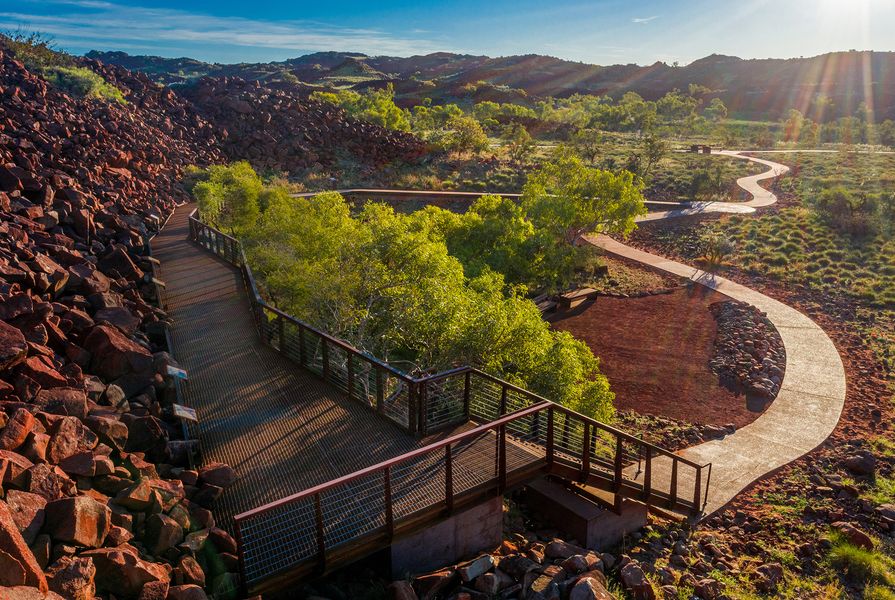
Murujuga (or the Burrup Peninsula) is a narrow strip of land and 42 nearby islands that has been nominated for inscription on the UNESCO World Heritage List in recognition of its outstanding natural and Aboriginal cultural value – the site features more than one million petroglyphs, the largest such collection in the world. Guided by the Murujuga National Park Management Plan 2013, the recently completed boardwalk, platforms and walking trail at the park’s Ngajarli (Deep Gorge), designed by the DBCA with The Murujuga Aboriginal Corporation, indicate a close attention to detail, a sensitivity to place and a finely tuned materiality. A visitor recreation masterplan for the area is currently being finalized.

Image: Fuzz Digital
The unit’s scope extends beyond site-scale design. For instance, the extensive work undertaken for the Nyinggulu (Ningaloo) Coastal Reserves Draft Joint Management Plan 2019 is the culmination of several years of intense collaboration with the Baiyungu Traditional Owners and the Yamatji Marlpa Aboriginal Corporation, local pastoral leaseholders, and state and local government agencies. This planning aimed to balance longstanding recreational use of the coastal reserve with conservation and natural and cultural heritage objectives, including access to recreation and camping along the highly visited Ningaloo Marine Park shoreline.
Altogether, more than 40 landscape architects have been involved in the DBCA since its beginning. They hail from Western Australia but also Victoria, New South Wales and overseas. From 2002 to 2007, I spent time with the unit as a landscape architect and its subtle, groundbreaking work has been a lasting inspiration. Indeed, the work of the DBCA offers an ongoing legacy that outlines exemplary and world-leading projects underscored by a sensitivity and respect for natural and cultural heritage as well as highly skilled approaches in the area of protected areas design and planning. Already well-recognized, the DBCA’s landscape architects continue to tease apart the interplay between conservation and recreation with their collective years of design knowledge and experience. And there is no end in sight. In 2019, the state government announced a plan to create five million hectares of new national and marine parks and reserves across Western Australia within five years. As of January 2021, the Plan for Our Parks program has already reserved an additional 313,000 hectares of protected area estate and the WA Recovery Plan, which will guide a post-COVID future, is underway. This means a swag of new projects for park planning and infrastructure in every corner of the state. These include projects as diverse as visitor infrastructure on the Houtman Abrolhos Islands to facilitate day use in the newly created national park, a recently unveiled 8,000-square-metre mural and new mountain-bike trail network at Collie, and works to key sites within Bunbury’s new Kalgulup Regional Park.
With many challenges ahead, we have only one shot at protecting our country’s natural and cultural heritage, while still providing the recreational opportunities that people seek – and it’s heartening to see that work of such a high calibre is under way in the west.
1. Government of Australia, “CAPAD 2018,” Australian Government Department of Agriculture, Water and Environment, environment.gov.au/land/nrs/science/capad/2018 (accessed 20 March 2021).
2. Government of Australia, “CAPAD 2018.”
3. Government of Western Australia Department of Biodiversity, Conservation and Attractions, Annual Report 2019–20, 25 September 2020, dbca.wa.gov.au/publications/annual-report-2019-20-department-of-biodiversity-conservation-and-attractions (accessed 20 March 2021).
4. Angela Stuart-Street, et al, Reading the Remote: Landscape Characters of Western Australia, Department of Conservation and Land Management, 1994
Source
Practice
Published online: 2 Jul 2021
Words:
Simon Kilbane
Images:
DBCA,
Fuzz Digital
Issue
Landscape Architecture Australia, May 2021