Peri-urban territories are defined by the intersection of urban and rural lands located at the fringes of an urban centre. They are dynamic territories undergoing constant transformation due to the multi-scalar processes brought about by urbanization. Peri-urban territories are framed by their local context and are specific to both place and time.1 Almost always becoming urban through a transformation of the rural, the process of peri-urbanization is often perceived as an improving process, as part of an urban-rural continuum of rural and urban zoned land. However, in many cases, this conversion can occur without a proper investigation of the collective and cumulative social and ecological value of these lands.
Peri-urban areas have a diverse array of functions. These functions are either a requisite of urban development, while being at the same time physically incompatible with it (for example, wastewater treatment plants, landfill sites, large-scale power infrastructure, industrial or manufacturing sectors); or they require large parcels of land to operate (agriculture, plantations, large-scale recreation and conservation estates). Peri-urban areas are often connected to each other by major road networks that circumnavigate the urban area and are interspersed with logistical hubs, often associated with airport and port areas, as part of global inter-city commodity chains. They also often contain a high number of threatened flora and fauna species – the endangered Banksia Woodlands, the predominant ecosystem along Western Australia’s Swan Coastal Plain, for instance, hosts the Carnaby’s black cockatoo, a threatened species which relies on these woodlands as a food source.2 Processes of peri-urbanization also commonly result in land being spatially fragmented, agricultural uses being dislocated and the water quality of surrounding systems – wetlands, creeks, catchments and estuarine areas – being reduced. This is despite such systems and agricultural and biodiverse areas providing essential ecosystem services3 that contribute to the health and wellbeing, liveability and resilience of human populations across a city’s entire metropolitan area.

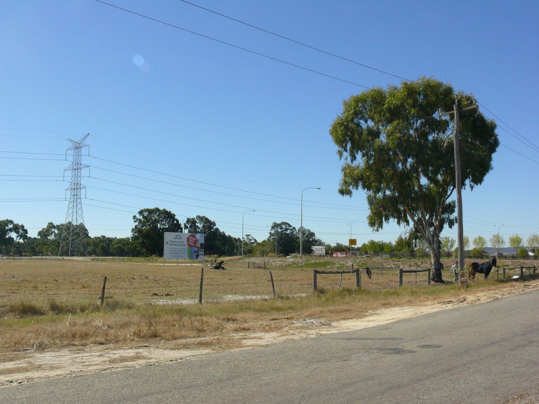
A remnant intensive agriculture area that has resisted urban development in Gnangara, a suburb of Perth.
Image: Sara Padgett Kjaersgaard
In Australia, peri-urban territories typically take the form of lower density, aging populations within rural areas surrounding our coastal urban metropolises.4 As land areas, they are subject to political, legal, governance and customary institutions.5 This also means we cannot (nor should we) ignore the intersection and unequal power distribution of settler-colonial concepts of land and land ownership with those of Aboriginal and Torres Strait Islander people, whose complex systems of land care and management of Country have been in place since time immemorial.6
By conceptualizing the peri-urban as a known territory, with characteristics that have critical value, rather than as landscapes waiting to become urban, we can act to shape human settlements in more considered and sustainable ways. We can begin by illuminating the discourse of urban sprawl – an urban form that has not been accidental. Secondly, we can examine the urban expansion policies of our metropolitan areas and the continued implementation of normative planning processes that support repetitive patterns of peri-urban urbanization and that deny other future landscape scenarios.
What role can landscape architecture play in this?
Landscape architects can play an important role in communicating the value of peri-urban territories and influencing future land use scenarios for these areas “beyond urban.” Landscape architecture, as a discipline and profession, has a rich history of engaging with the urban fringe, from the creation of peripheral parklands as a response to industrialisation in the nineteenth century to the protection of countryside as an antidote to the city, as projected in the principles of the garden city. As a composite discipline that draws on knowledge from the natural and social sciences, landscape architecture is well-positioned to consider natural processes and cultural practices equally and bring them together in a transdisciplinary way to move towards the sustainability goals outlined and embedded in the United Nations’ Sustainable Development Goals7 and its New Urban Agenda.8 The COVID-19 pandemic has indicated how essential our fringe metropolitan landscapes are in supporting the liveability, health and wellbeing of residents. These areas are vital for metropolitan areas. They provide basic raw materials for urbanization, food and opportunities for recreation and respite, delivering an array of preventive health measures.9
What can the peri-urban be, if not a by-product of urbanization? Urban theorist Neil Brenner has argued that peri-urban territories can be understood as a rescaling of embedded urbanization processes and hierarchies that determine the production of this space.10 For landscape architects, this suggests thinking and practices that can disrupt and restructure the relationship between people and nature to form new multi-scalar, socio-cultural and socio-spatial networks. Landscape design at the scale of landscape planning is necessary to increase the value of peri-urban territories and their natural systems.11 Design provides a significant opportunity to improve the environmental, social and economic performance of landscapes; in highly fragmented landscapes like the peri-urban, the quality of such structures is paramount. Furthermore, to use landscape as opposed to urban form as the dominant structuring element of peri-urban areas allows the landscape character types, cultural markings and ecological systems pronounced within the fringe areas of the city to be elevated.

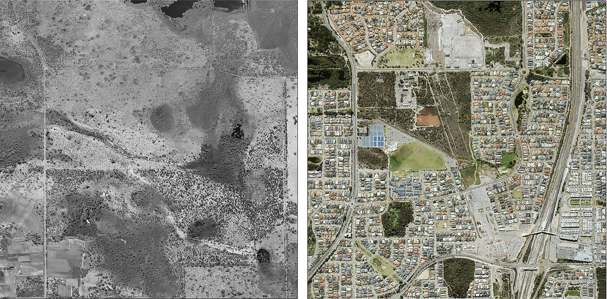
Comparative images from 1953 (left) and 2016 (right) of a peri-urban area south of the city of Perth.
Image: Government of Western Australia, Landgate “Geospatial data.” Midland, WA, 2010.
The ecological, social and economic impacts of climate change in Australia urgently call for our peri-urban territories to work harder and perform better. Consider the imperatives underscored in the United States’ Green New Deal – decarbonization, justice and jobs.12 Each are a suite of intersections that could function to reimagine peri-urban areas as designed places actively responding to climate change issues. Engaging with the peri-urban as territory means considering not just how we approach the physical transformation of these areas through the processes of urbanization, but also how we engage the socio-ecological networks required to support an increasingly urban nation. To approach the peri-urban as a
site for landscape architecture “beyond urban,” is to see it as a distinct territory
with its own unique conditions and opportunities – aspects that landscape architects are well-positioned to engage with in far greater depth. By actively participating in debates around the future of these areas, landscape architects can influence the direction of new knowledge, thinking and the design of these understudied and undervalued territories.13
1. John Friedmann, “The future of peri-urban research,” Cities, vol 53, 2016, 163–165
2. Sarah Coleman, “Australia state of the environment 2016: built environment,” State of Environment website, 2017, https://soe.environment.gov.au/sites/default/files/soe2016-built-launch-20feb.pdf?v=1488792899 (accessed 17 May 2020)
3. Millennium Ecosystem Assessment, “Ecosystems and Human Well-being: Synthesis,” Millennium Ecosystem Assessment website, 2005, https://www.millenniumassessment.org/documents/document.356.aspx.pdf (accessed 19 November 2020)
4. Michael Buxton and Andrew Butt, The Future Of The Fringe, (Clayton South: CSIRO Publishing, 2020)
5. Andre Sorensen, “Periurbanization as the institutionalization of place: the case of Japan,” Cities, vol 53, 2016, 134–140
6. Libby Porter, “From an urban country to urban Country: confronting the cult of denial in Australian cities,” Australian Geographer, vol 49 no 2, 2018, 239–246
7. “United Nations Sustainable Development Goals,” United Nations Division for Sustainable Development Goals website, https://sdgs.un.org/goals (accessed 19 November 2020)
8. “New Urban Agenda,” United Nations Conference on Housing and Sustainable Urban Development website, 2017, https://habitat3.org/wp-content/uploads/NUA-English.pdf (accessed 31 October 2020)
9. Australian Government Department of Health, “Australia’s Long Term National Health Plan,” Department of Health website, August 2019, https://www.health.gov.au/sites/default/files/australia-s-long-term-national-health-plan_0.pdf (accessed 19 November 2020)
10. Neil Brenner, New Urban Spaces: Urban Theory and the Scale Question (New York: Oxford University Press, 2019)
11. Three recent AILA award-winning projects do just that. The Western Sydney Parklands Plan of Management 2030 and the Western Sydney Parklands Design Manual by Western Sydney Parklands Trust in 2019, and the Eastern Regional Trails Strategy by Fitzgerald Frisby Landscape Architecture in 2020.
12. Recognizing the duty of the Federal Government to create a Green New Deal, H.R. Res. 109, 116th Cong. (2019)
13. There has been extensive research into peri-urban areas conducted over the past 20 years through research partnerships between RMIT University, Griffith University and La Trobe University. This has contributed to some major policy revisions for Melbourne and south-east Queensland’s broader metropolitan regions. However, planners and policy makers have led this research. I argue that the addition of landscape architecture perspectives, knowledge and skills would enrich this body of research.
Source
Practice
Published online: 9 Apr 2021
Words:
Sara Padgett Kjaersgaard
Images:
Government of Western Australia, Landgate “Geospatial data.” Midland, WA, 2010.,
Sara Padgett Kjaersgaard
Issue
Landscape Architecture Australia, February 2021