The Western Sydney Aerotropolis is a multi-billion-dollar development that aspires to be the third-largest economic centre in Australia by 2036, ten years after the airport it’s centred on is set to open. A range of high-powered global Fortune 500 companies have already signed up as Foundation Partners with the New South Wales state government to contribute to and be part of the development. Defence, manufacturing and tech companies such as Northrop Grumman, Samsung, Mitsubishi, Siemens and Hitachi are vying to build centres and facilities developing data analytics, advanced manufacturing, intensive agriculture, artificial intelligence and other technologies that will underpin the aerotropolis’s smart city and sustainability credentials. Likewise, public institutions such as the CSIRO, the Australian Space Agency and a consortium of Australian universities aim to make this a “knowledge” or “innovation” district. The aerotropolis promises to tip the scales of opportunity a little more toward Sydney’s typically disadvantaged western edge. However, the new city will have to deliver not just for the locals, but globally, if the new economy is to attract the kind of highly mobile, specialist talent it requires. This means that the aerotropolis, and Western Sydney more generally, will have to be a highly attractive place for people to live, work and travel to in its own right – a global destination, a place where ideas, things, organisms and people are linked with the world. This is to be a bustling, around-the-clock city with plenty of nightlife and other activity to occupy, enjoy and distract, perchance the 24-hour aircraft noise keeps you up.1

Aerotropolis Masterplan by Hassell (Aerotropolis Core, Badgerys Creek), Hill Thalis (Northern Gateway) and Studio Hollenstein (Agribusiness).
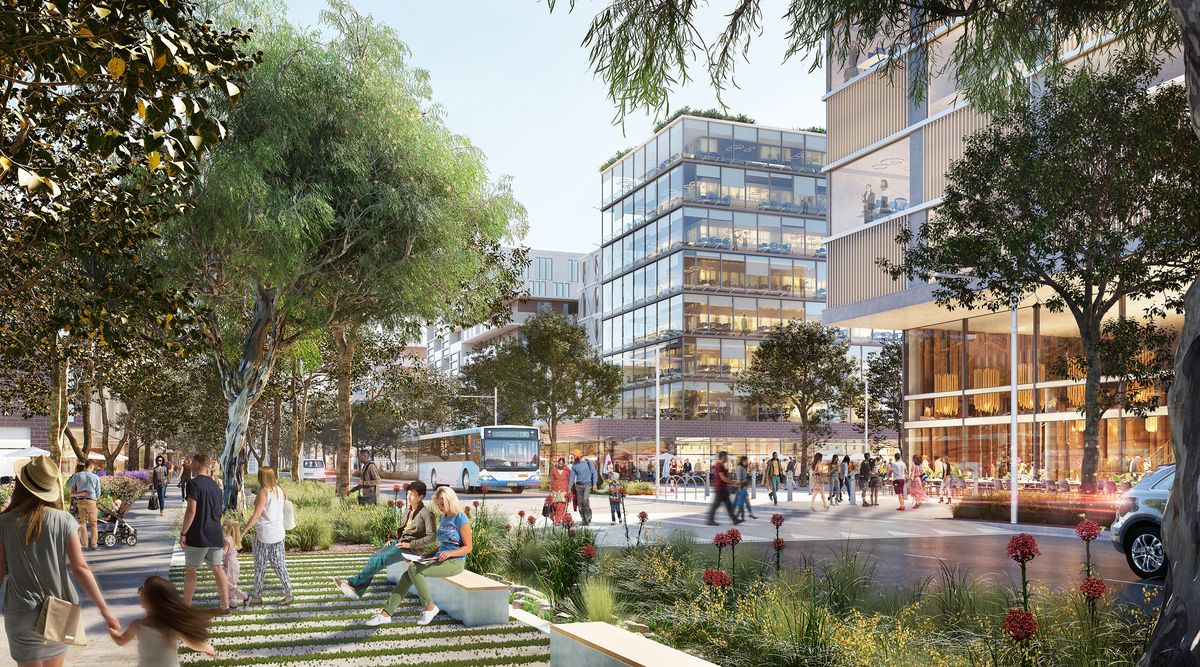
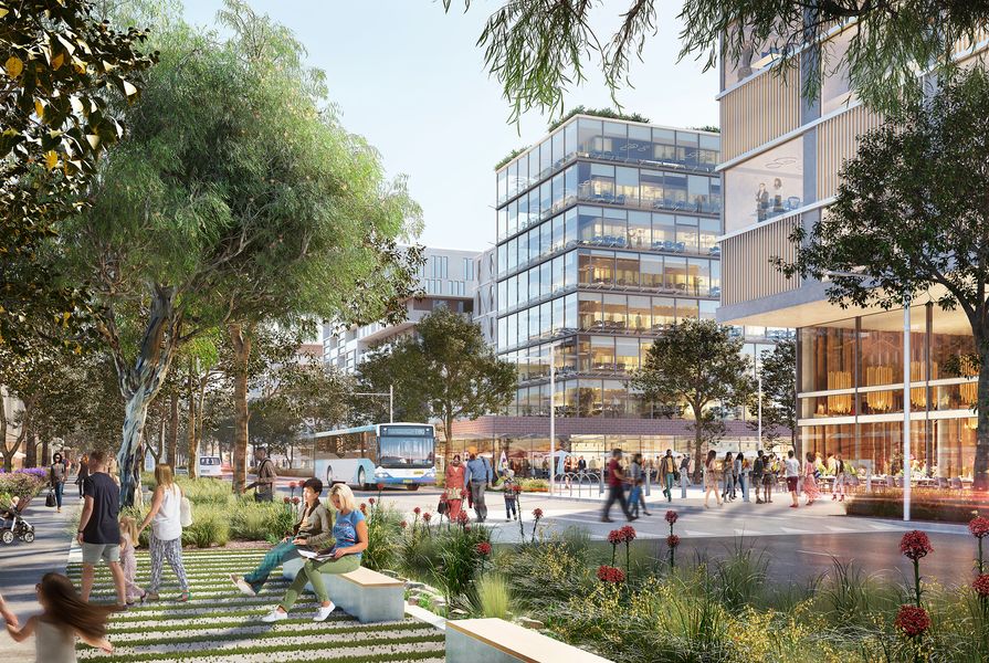
Some of Sydney’s best urbanists have been hard at work shaping this challenging vision over the past six to twelve months. It is not an easy task. The work so far takes Sydney’s metaphoric “Western Parkland City”2 concept as its foundational starting point and attempts to design the various precincts that make up the 11,000-hectare development using a “landscape-led approach.” In some ways, this appears to be the latest version of greenwash. How can the design be “landscape-led” if motorways are the first elements implemented, without careful and collaborative consideration of the city’s future urban form and habitation? The motorways for the city are already largely in, having flattened many fine and characterful tree-lined country roads that could have benefited the future city. Isn’t it time that we recognize motorways for the obsolete twentieth-century infrastructure that they are? Transport authorities might have considered a more sustainable and intensive development of the metro or other transport alternatives for a more future-focused city. In an area the size of Manhattan, three metro stations and a rapid bus transit system do not seem quite enough to make the city walkable.
Despite such transport limitations, there are clear signs that the landscape-led approach has been carried through to the preliminary designs for the precincts. Tyrrell Studio and Infrastructure NSW initially developed important landscape principles to guide the draft precinct plans of the three selected consultant teams. The guiding principles recognize the fragile and distinctive qualities of Western Sydney’s blue-green landscape systems and conceive of them as city-shaping opportunities that can offer exhilarating experiences for future urban residents. Key principles include the preservation of chains of farm dams through future water elements, and the preservation of the fine hilltop views and riparian valleys through street easements and park systems. In essence, the principles aspire to conserve and knit together the critically endangered remnant Cumberland Plain Woodland and River-flat Eucalypt Forest, along with the most beautiful and important aspects of the agricultural landscape, within close proximity to the new high-density urban centres.

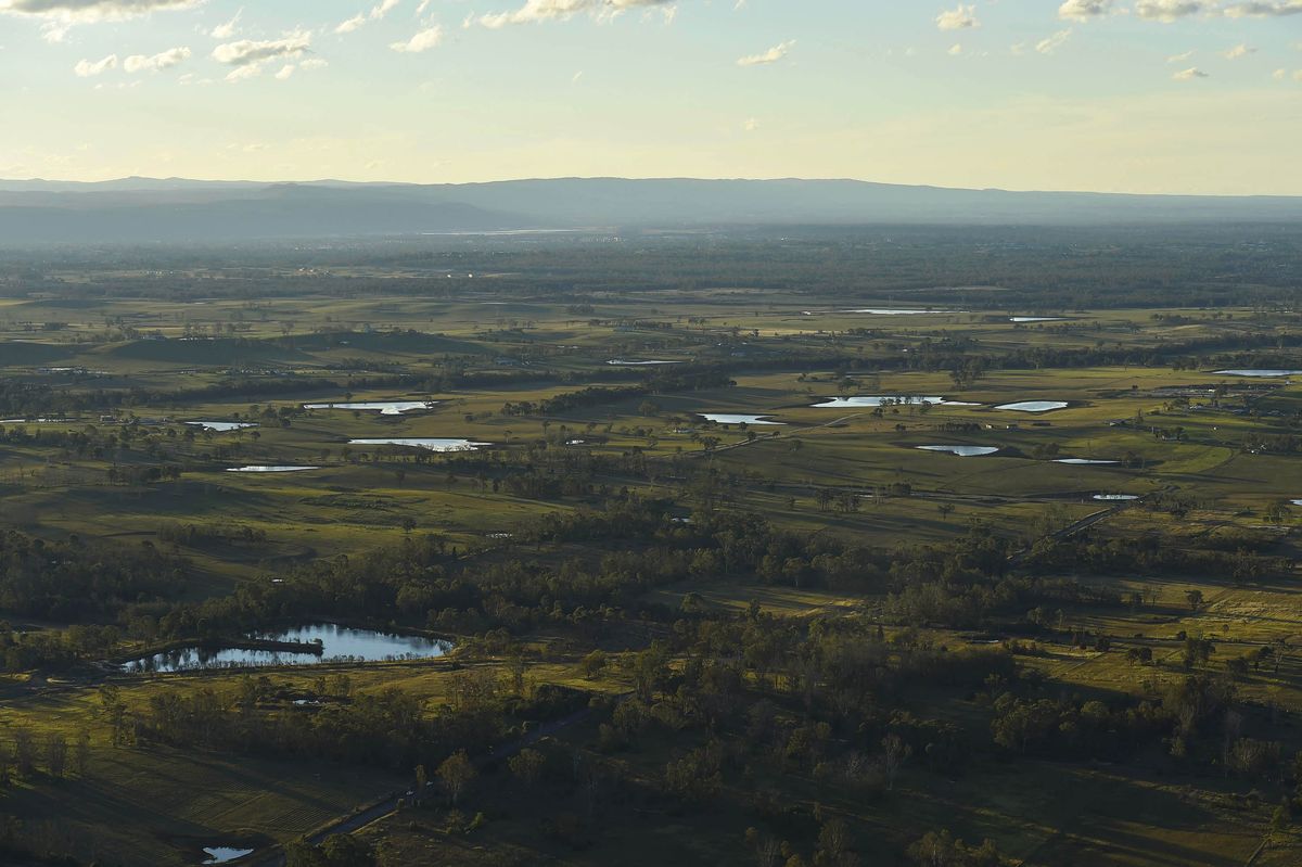
An aerial view of the farm dams and undulating topography of the South Creek Catchment.
Image: Greater Sydney Commission, 2018
One of the most exciting and admirable aspects of the draft precinct plans is the extent to which they have analyzed, mapped and integrated a range of important and often overlooked systems into their layouts, guided by such landscape principles. Various biophysical systems, such as living soil landscapes and hydrology, have been considered in relation to cultural systems and the Country of the local Deerubbin, Gandangara and Darug peoples. Although the mapping methodology is not always explicit, the intent is significant and hints that a new hierarchy of planning considerations is within reach.
Design scenario workshops helped the consultants to examine the benefits and trade-offs involved in integrating the green systems. The three lead consultants, Hassell, Hill Thalis Architecture and Urban Projects and Studio Hollenstein, in collaboration with landscape architects JMD Design and Taylor Brammer Landscape Architects, have each developed three different scenarios for their respective precincts. A clear outcome of such scenario planning is that Duncans Creek reservoir, Cosgroves Creek, Thompsons Creek and Badgerys Creek are the green centrepieces for the new precincts. A patchwork of ridge-top parks complements the blue-green filigree dispersed through the districts, bringing a complexity and diversity to the urban precincts.
Perhaps the clearest series of diagrams is that by Hill Thalis; it explores the consequences of aligning grids with the topography instead of conforming to the existing grids and lots. The outcome involves less damage to creek systems and better alignment with Country. Both Hassell and Studio Hollenstein focused on how different configurations of development clusters and alternative zonings could either fragment or complement existing creeks and waterways. Their zoning-based approach has produced a plan that reads as a city in a park, like a series of oversized campuses. Hassell has dispersed the aerotropolis core around Thompsons Creek to take advantage of government land ownership patterns and the location of the metro stop. This fragmented arrangement does not suggest a 24-hour urban intensity. However, the central green elements may provide important cooling ventilation pathways from the creeks to the hilltops and vice versa. Although climate consultants have informed the design process, the type of “climatope” modelling that is the norm in countries such as Germany, Sweden and the Netherlands3 hasn’t been completed for the draft precinct plans. “Landscape” is instead presented as a normative climatic good.

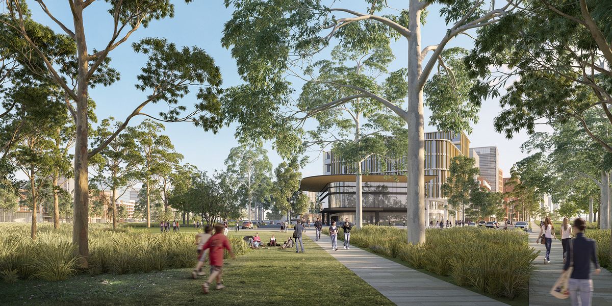
A visualization of the central riparian park within the Northern Gateway precinct’s specialized centre, an area focusing on employment that is envisaged to develop around the future metro station.
Image: Hassell
Western Sydney has, at times in 2020, been the hottest city on the planet – and it will get hotter if it continues to urbanize.4 Will blue and green infrastructure-based strategies be enough? The chair of the recently formed AILA Climate Positive working group, Martin O’Dea, has said that by 2036, “the daily projected increase in runoff for nearby South Creek from urbanization and treated sewerage flows will be greater than the maximum output of the Sydney Desalination plant.”5 He has suggested that the city could use the runoff to increase soil moisture profiles and cool the landscape using permaculture-based technologies such as wicking beds. Sydney Water strategist Phillip Birtles agrees and suggests that provision of deep soil zones and ample space for trees in both the private and public domain are essential to cool the city and prevent the development of “urban stream syndrome,” which would destroy South Creek.6 Such approaches, however, may exacerbate existing salinity problems, which are making the soil infertile – there is no easy way forward. Cooling the city and achieving the parkland vision will also be difficult because of airport risk-management strategies, such as limiting biodiversity for vast areas around the runway to prevent bird collisions.7 Alluvium Consulting, the UTS Institute for Sustainable Futures and Mosaic Insights have devised a forward-thinking list of circular economy principles for the aerotropolis,8 but too many practical sustainability innovations are still on the drawing board, long after the grey infrastructure has already been decided upon.
Critics of the aerotropolis model9 suggest that airport-based urbanism doesn’t typically have the ambience and pull of historic city centres when it comes to attracting global knowledge workers. However, with heatwaves and environmental challenges, this may be the least of the aerotropolis’s worries. Extreme heat, Australia’s most deadly climate-related threat, will endanger the wellbeing, health and lifespans of Western Sydney residents. Current research projects that days over 35 degrees Celsius will increase fivefold, to 52 days a year, by 2090 – and more, in some neighbourhoods – if drastic global emissions reductions do not eventuate.10 It is clear from the many contradictions at the heart of the Aerotropolis-Parkland-City concept that it is not an ideal city-making vision. A landscape-led approach may help to temper its more negative aspects. Regardless, a much more radical reckoning with the city’s future climatic conditions is needed, if the future city is to be liveable.
1. Benedikt Boucsein, Kees Christiaanse, Eirini Kasioumi and Christian Salewski, The Noise Landscape: A spatial exploration of airports and cities (Rotterdam: Nai010 Publishers, 2017).
2. Western Parkland City Authority website, wpca.sydney/western-parkland-city, (accessed 14 December 2020).
3. See Edward Ng and Chao Ren, The Urban Climatic Map: A Methodology for Sustainable Urban Planning (New York: Routledge, 2015) and Chao Ren et al, “Urban Climate Map System for Dutch Spatial Planning,” International Journal of Applied Earth Observation and Geoinformation, vol 18, 2012, 207–22 and Sandra Lenzholzer, Weather in the City: How Design Shapes the Urban Climate (Rotterdam: Nai010 Publishers, 2015). In 2018, the author also ran a series of aerotropolis design studies investigating the relationship of urban microclimate and urban design at the meso and precinct scale. This work has been published in Thomas Fisher, Brian Orland and Carl Steinitz, The International Geodesign Collaboration: Changing Geography by Design, (Brisbane: Esri Press, 2020), 68–69.
4. Mark Ogge, Bill Browne and Travis Hughes, “HeatWatch: Extreme Heat in Western Sydney” (Canberra: The Australia Institute, 2018), tai.org.au/content/heatwatch-extreme-heat-western-sydney-0 (accessed 8 December 2020).
5. Martin O’Dea, “Use It or Lose It: The Value of Urban Stormwater in Cooling our Cities,” Stormwater Australia National conference, Sydney, 2018, www2.slideshare.net/MartinODea2/use-it-or-loose-it-the-value-of-urban-stormwater-in-cooling-our-cities?from_action=save (accessed 8 December 2020).
6. Phillip Birtles, “South Creek in Far Western Sydney: Opportunities for a New Waterway Focused City,” 2020, in Rob Roggema (ed.), Nature Driven Urbanism (Cham, Switzerland: Springer, 2020), 213–215.
7. Eco Logical Australia 2020, Western Sydney Aerotropolis – Draft Biodiversity Assessment (Western Sydney Planning Partnership, October 2020), 47.
8. Draft Sustainability and Heat Report – Western Sydney Aerotropolis, Mosaic Insights, Institute for Sustainable Futures and Alluvium Consulting, October 2020.
9. Michael Charles, Paul Barnes, Neal Ryan and Julia Clayton, “Airport Futures: Towards a Critique of the Aerotropolis Model,” Futures, vol 39 issue 9, 2007, 1009–1028.
10. Mark Ogge, Bill Browne and Travis Hughes, “HeatWatch: Extreme heat in Western Sydney.”
Source
Practice
Published online: 26 Feb 2021
Words:
Scott Hawken
Images:
Arterra Interactive and Hassell.,
Greater Sydney Commission, 2018,
Hassell
Issue
Landscape Architecture Australia, February 2021