Landscape Australia: Could you tell me about your role at the City of Melbourne?
Margie McKay: I lead a team of ten urban designers within the City Design Studio at council. The City Design Studio also has a landscape architecture team, an industrial design team and an architectural team, but my team is involved in the strategy and policy end of the design scale and a key part of our work involves providing design advice. It’s a pretty exciting time to be working at the City of Melbourne with the large amount of development that’s happening in the city and the significant changes that are coming through major infrastructure projects and extensive private development. We’re seeing enormous growth and change in the central city.
LA: The Melbourne Transport Strategy 2030 was two years in the making. What are some of the key issues that have driven the strategy?
MM: One of the strategy’s key directions is about supporting the walking economy. Within the Hoddle Grid of the central city, 89 percent of the trips are by foot, but currently only 20 percent of the road space is allocated to pedestrians. So, there’s a really large disparity in terms of decisions around priorities that have been made in the past. Walking is the most spatially efficient form of transport, followed by public transport and cycling, and this has driven the strategy’s priorities and framing. The other reason there’s such a strong focus on walking in the strategy is because of how people experience a city. Melbourne is very much moving towards a knowledge economy and that sort of face-to-face contact of people rubbing shoulders with each other – while quite challenging at the moment because of social distancing – is a key reason why businesses are locating themselves in the central city, for the clustering of activities and the sharing of ideas. Walking as a form of [activity] very much supports that type of interaction and the “liveability” side of the city.1
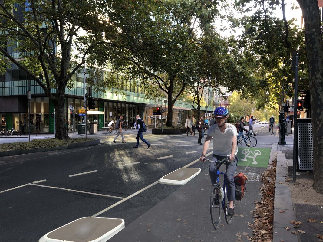
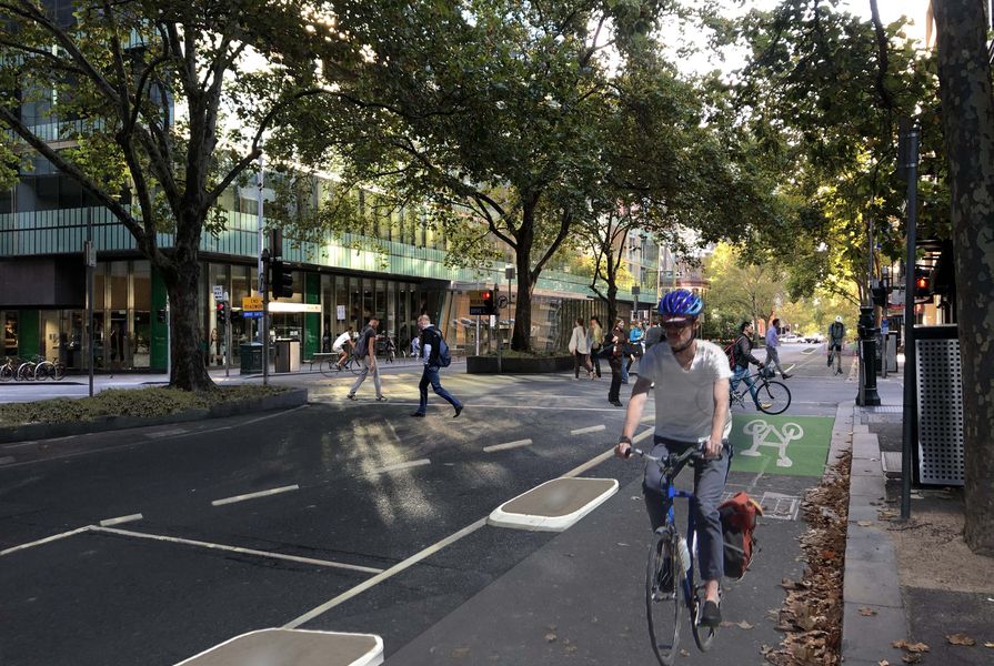
The strategy also aims to make Melbourne into a leading cycle city. A key ambition was to increase the amount of protected cycle lanes. The evidence that supported the strategy included physical evidence around areas of pedestrian congestion and so forth, but also behavioural evidence around why people make the transport decisions that they do. One of the most compelling surveys, that informed our planning, revealed that safety was a key factor in deterring cycling. Providing cycle lanes that are protected from vehicles could encourage people who wouldn’t normally choose cycling as a form of transport to give it a go.
LA: What changes has the City, and your work, seen since March, when the pandemic began to take effect here?
MM: Population growth has slowed, there’s been a stalling in terms of overseas migration. [Before COVID-19] Melbourne was on such a growth trajectory, growing more rapidly than Sydney as one of the fastest-growing cities in the OECD. In some ways [the pandemic situation] has given us a little bit of breathing space to catch up from an infrastructure perspective. Certainly, our work at the City hasn’t slowed down at all – we’re still seeing a huge amount of development applications coming through and we’ve also got COVID stimulus projects that we’re working on.
LA: How has the implementation of the strategy been altered by the pandemic, the ongoing lockdowns and changes to the use of public space?
Originally, as part of the strategy’s implementation, the cycle lanes were planned to roll out according to a 10-year schedule, however in January this year, the City of Melbourne declared a climate emergency, which led to fast-tracking the cycle implementation to four years. At the time we thought, this is really challenging, how are we going to do this in four years? But now with the COVID situation, we’ve been trying to get the cycle lanes on the ground as soon as possible, to provide a form of transport where people can feel like they can socially distance safely and still be able to access work and the services in the CBD.
LA: Are there other aspects of the strategy that have been reshuffled in terms of priority in response to recent conditions?
MM: Yes, another major part of the strategy looks at the little streets within the central city which currently have a strong service orientation. The primary streets are where most buildings front the street and more of the loading, servicing and car park access happens from the little streets, for instance along Flinders Lane. The strategy recognizes that the little streets have a fine-grained character and support a lot of pedestrian movement as well as liveability in the city. There was an opportunity to use the little streets to integrate the laneways and spread Melbourne’s well-loved laneway culture. As part of the COVID-19 work, we’re reducing speed limits on the little streets and making them into pedestrian priority shared zones.
City of Melbourne has also been working on improving the central city transport hubs. Flinders Street station area, for example, is more than our busiest train station – in fact the tram stop outside Flinders Street station is the busiest tram stop in Australia and has more passengers getting on and off, than most suburban train stations. The strategy looks at these major transport hubs as key gateways to the city and aims to improve not only the efficiency of people getting from tram to train or getting in and out of the stations, but the civic and urban design quality of these spaces and their presentation to the city. In many cases, they’re the first part of Melbourne that visitors see when they arrive, they’re major gateways into the city. In response to the pandemic however, this work has been shifted downwards in priority, as the number of people using public transport at the moment is quite low, and even when people start returning to work, hours will likely be staggered with continued partial working from home. At the moment, cycling and walking programs are taking priority.

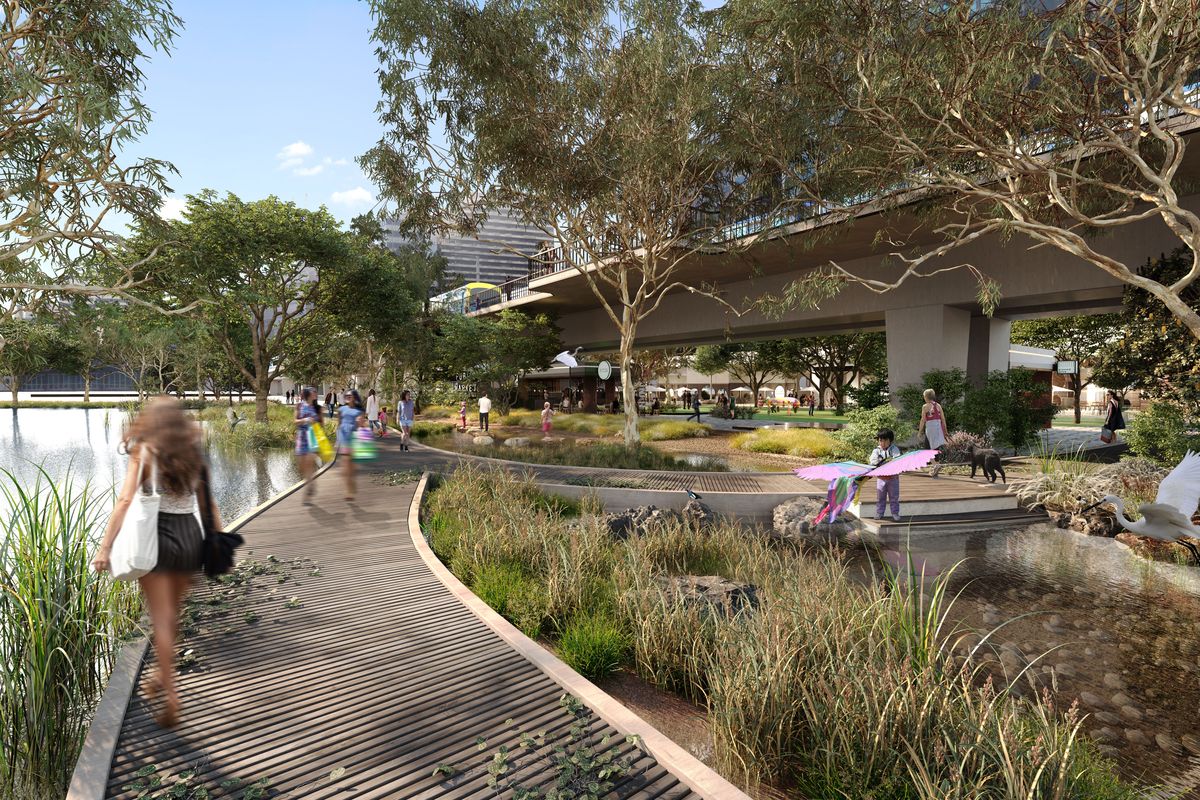
Renders from the Yarra River – Birrarung Strategy showing the future potential of the river’s north bank.
Image: FKD Studio
LA: It’s certainly a time of accelerated change – what other discussions are you drawing from in terms of shaping the future development of the City?
MM: There’s been really strong discussions around localization and people connecting with the local place where they’re living, so that may be a factor that changes the way the city develops going forward. In the central city, our population of local residents is rapidly growing – the suburb of Melbourne is one of the fastest growing residential populations. Obviously, it’s a shift that’s been happening over the past 20 years or so, (since the Postcode 3000 policy began in the 1990s) but I still think there’s quite a way to go in terms of seeing the city not just as an employment and entertainment hub, but as a place to live. Thinking in these terms really shifts the way we think about things like the use of streets or the use of parks and their public role. Over the lockdown period since March we’ve seen places like the Tan (a running track around Melbourne’s Royal Botanic Gardens) absolutely overrun with incredible numbers of people using them. A key trend moving forward I think will involve looking at how we can design the public spaces in the city to support local users – not just visitors or people coming in and out of the city, but that day-to-day local use as well.
Other key trends around that localization are going to be around local identity and authenticity. A completely different piece of work that our team has been working on recently is the Yarra River – Birrarung Strategy which focuses on the central city part of the river. A key part of that project has been looking at the role the river has played in Melbourne’s identity, looking back to pre-European times and the central role the river had and continues to have for the traditional owners. How do we embrace the qualities of the river as an Australian city rather than using European references? How do we enrich the approach to landscape as well the stories, uses and activities from a local Melbourne approach, so we are creating our own river experiences rather than just experiences that looks to other parts of the world. I think these trends around localization, local identity and the “authentic” context are going to become much stronger in the future.
1. The Transport Planning team in City Strategy led the development of the Transport Strategy with advice from Urban Design and other experts across Council. A multidisciplinary team including landscape architects from City Design Studio are currently delivering the Strategy.