Imagine a 1,000-kilometre-stretch of dead trees along the eastern coast of Australia – let’s say the popular stretch from Byron Bay to Sydney. Mangroves and the estuaries they inhabit are just grey sticks standing forlorn against a skyline of emptied tidal creeks. What would be the reaction? One of outrage, with calls for action and answers? This is the exact plight of an equal length of shoreline, up to 200 metres wide in places, in the Gulf of Carpentaria, straddling the shorelines of Australia’s Northern Territory and Queensland. Yet the silence and inaction regarding this site are palpable.
The demise of mangrove shorelines in Australia is an emerging coastal catastrophe that is literally happening before our eyes. The resources lost and threatened last year amount to $379 million, based on Queensland Government estimates of fisheries (or marine plant) values alone for the area affected by this incident.1 It’s time we spared a thought for the struggling northern seafood industry and seriously considered the other implications, for now and in the future, of increasing mangrove dieback.
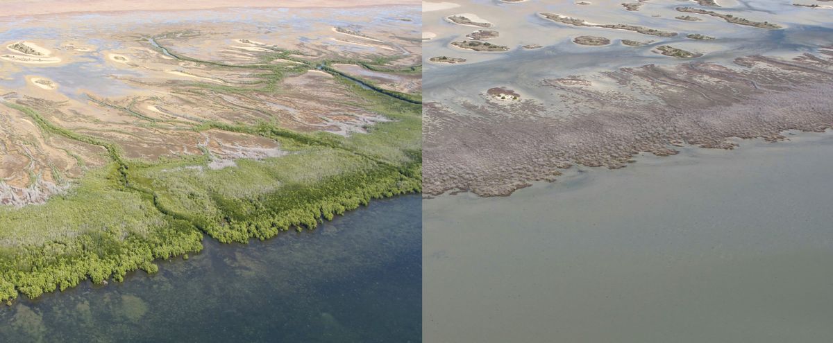
In the latter part of 2015, when mangroves died back en masse along this 1,000-kilometre stretch of the Gulf of Carpentaria coastline, more than 7,400 hectares of forested tidal wetlands died in a single month.2 This unusually severe mangrove dieback is the largest recorded incident of its kind, and national and international tidal wetland specialists agreed it was the worst instance of likely climate-related dieback ever reported.3 It evokes significant and profound questions, such as what were the causes, what are the consequences, and what is being done about it? And is it significant that the dieback incident more or less coincided with the coral bleaching taking place on Australia’s north-east coast that summer?

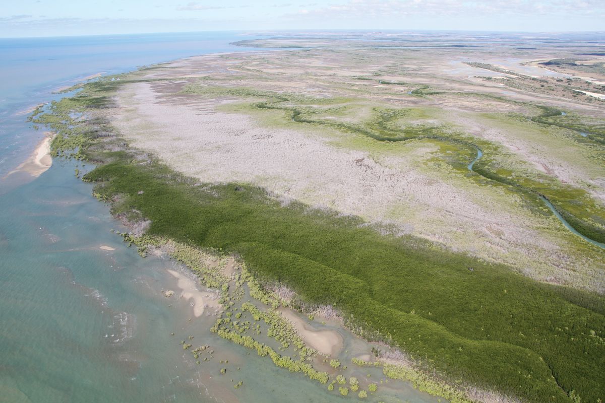
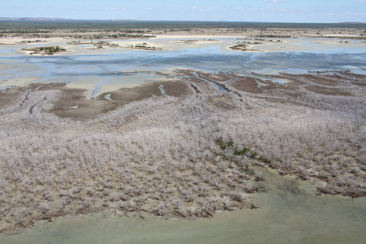
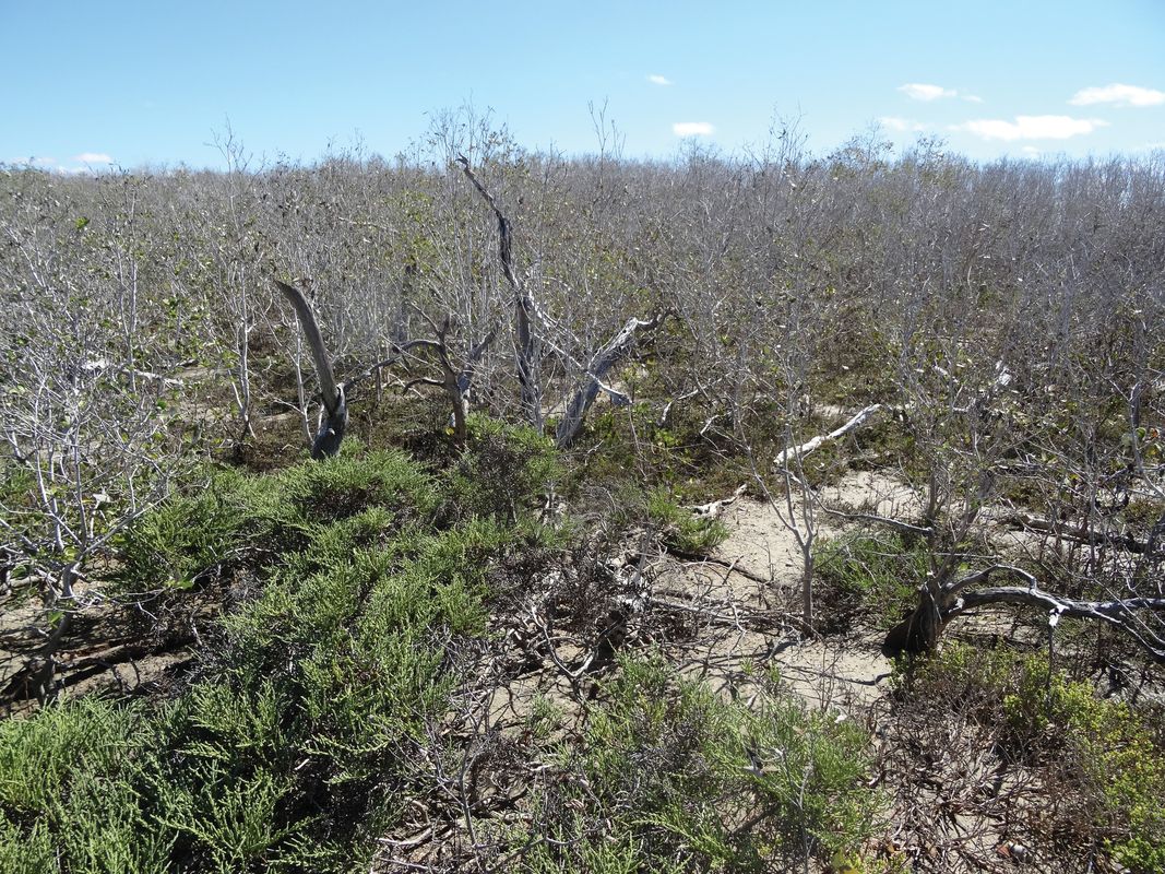
Mangrove dieback is most severe and widespread across the southern Gulf of Carpentaria, from the Northern Territory to Queensland.
Image: Norman Duke
One thing we learn from this incident is that mangroves, like coral reefs, are vulnerable to changes in climate and extreme weather events. Mangrove forests occupy the upper intertidal shoreline zone, an often harsh environment of daily inundation, notable salinity and anoxic soils. Tolerance of these factors is a critical determinant of overall mangrove distributions, 4,5 along with the broad influences of temperature, rainfall, size of upstream drainage catchments, and the availability of viable propagules. In Australia, the most significant stands occur along the eastern and northern wet tropic coastlines of north Queensland, extending to the wet/dry tropics of the Northern Territory and Western Australia.6
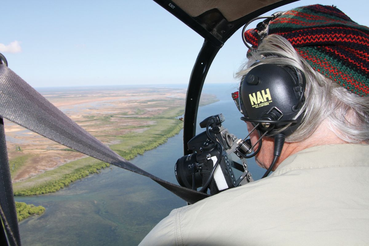
In early 2016, soon after hearing about the severe dieback and viewing photographs received from concerned locals, a small team of scientists at James Cook University’s TropWATER Centre and MangroveWatch initiated an urgent investigation. A key motivation was to get critical on-site evidence before it was lost forever. Evidence was also gathered from public databases to identify prevailing climate conditions, sea level data and satellite imagery. These resources – along with feedback from local community members and others on the ground, and limited field surveys completed with the Northern Territory Government and the Queensland-based Carpentaria Land Council Aboriginal Corporation – allowed a somewhat better understanding of the incident, its extent, its timing and the likely causes.2
So far the investigative work on the mangrove dieback has involved first-order mapping and compilation of influencing factors affecting mangrove vegetation. This has revealed more or less continuous levels of severe impact along the southern Gulf of Carpentaria, from the Northern Territory to Queensland. A key parallel task of TropWATER scientists was to respond to community concerns about finding ways to assist local observers to make more effective contributions toward shoreline management. This has started, and it involves training and equipping Indigenous rangers and local community volunteers to apply rigorous shoreline assessment methods. Rangers and community members are keen to do whatever they can to help the situation.
As mangroves of Australia’s Gulf region have experienced relatively little anthropogenic impact, they are considered the least altered mangrove ecosystems in the world.4 So the relative dominance of climate influences in this region is of critical interest to world observers of environmental responses to climate change. The climate of the southern Gulf coastline is wet/dry tropical, with regional annual rainfalls between 600 and 900 millimetres. Rainfall is notably seasonal, with a typically regular dynamic of summer monsoons and intervening winter drought conditions for six to nine months of the year. Tropical cyclones occur irregularly but predominantly during summer. However, over recent years there have been no reported impacts and certainly none during the latter part of 2015, when the severe dieback occurred.
To put it in a nutshell, current investigations show the sudden and widespread onset of severe dieback, affecting more than 6 percent of mangrove vegetation along the Gulf coastline. This was associated with an event of extreme weather,7 localized around the southern Gulf region from the Roper River estuary in the Northern Territory to Karumba to the east in Queensland – a distance of more than 1,000 kilometres. The dieback coincided with an unusually lengthy period of severe drought, unprecedented high temperatures and a temporary drop in sea level.
Moisture stress is considered the most likely cause of this severe mangrove dieback. Patterns of impact seen in mapping and the aerial surveys are consistent with this kind of response. Stresses from water deficits were particularly acute up to the end of the 2015 dry season. Furthermore, during the previous four years, this coastline experienced below-average rainfalls, when the monsoons were weak and active only for six to eight weeks of each wet season.8 These influences combined with low cloud cover are likely to have resulted in unusually high levels of radiation, air temperatures and evaporation rates. And while the micro-tidal Gulf shorelines have generally experienced high rates of sea level rise over the past twenty-five years, circumstances were oddly reversed temporarily with a drop of twenty centimetres during the latter months of the 2015 dry season. These circumstances and the very low topographic coastal gradients, increased hydroperiod duration and periods of hypersalinity appear to have all contributed to a lethal combination of reduced inundation and thermal, radiant and moisture stresses on fringing mangrove stands. This is consistent with the influence of other variables, including the general lack of anthropogenic or other natural disturbances,9 the extensive area affected and its synchronous occurrence across the region.
The take-home message is that these marine coastal habitats are indeed vulnerable to changes in climate, as well as to more direct human pressures. There needs to be funding for rapid-response assessments, along with a dedicated, independent advisory panel to coordinate the follow-up actions undertaken. While we urgently need to know more about this emerging issue, we also need to better appreciate the value of our precious mangrove places and the benefits they give us.
1. Queensland Government Offset Calculator [environment.ehp.qld.gov.au/offsets-calculator]
2. Norman C. Duke, John M. Kovacs, Anthony D. Griffiths, Luke Preece, Duncan J. E. Hill, Penny van Oosterzee, Jock Mackenzie, Hailey S. Morning and Damien Burrows, “Large-scale dieback of mangroves in Australia’s Gulf of Carpentaria: a severe ecosystem response, coincidental with an unusually extreme weather event,” Marine and Freshwater Research (CSIRO Publishing: forthcoming).
3. See “Latest AMSN News – the Australian Mangrove and Saltmarsh Network” for more information [research.jcu.edu.au/tropwater/research-programs/australian-mangrove-and-saltmarsh-network/latest-amsn-news]
4. Norman C. Duke, Marilyn C. Ball and Joanna C. Ellison, “Factors influencing biodiversity and distributional gradients in mangroves,” Global Ecology and Biogeography Letters , vol 7 no 1, January 1998, 27–47.
5. Beth Crase, Adam Liedloff, Peter A. Vesk, Mark A. Burgman and Brendan A. Wintle, “Hydroperiod is the main driver of the spatial pattern of dominance in mangrove communities,” Global Ecology and Biogeography , vol 22 issue 7, July 2013, 806–817.
6. Norm C. Duke, Australia’s Mangroves: The Authoritative Guide to Australia’s Mangrove Plants (Brisbane: University of Queensland, 2006).
7. Bureau of Meteorology, Special Climate Statement 51 – an exceptional autumn hot spell in northern and central Australia (Bureau of Meteorology, 2015), bom.gov.au/climate/current/statements/scs51.pdf (accessed 18 November 2016).
8. Marilyn C. Ball, “Ecophysiology of mangroves,” Trees , vol 2 issue 3, March 1998, 129–142 (1988).
9. Norman C. Duke, “Mangrove Coast,” in Jan Harff, Martin Meschede, Sven Petersen and Jörn Thiede (eds), Encyclopedia of Marine Geosciences (Netherlands: Springer, 2014), 412–422.
Source
Practice
Published online: 2 May 2017
Words:
Norman Duke
Images:
Norman Duke
Issue
Landscape Architecture Australia, February 2017